Little River Canyon National Preserve
National Park Service — Little River Canyon National Preserve
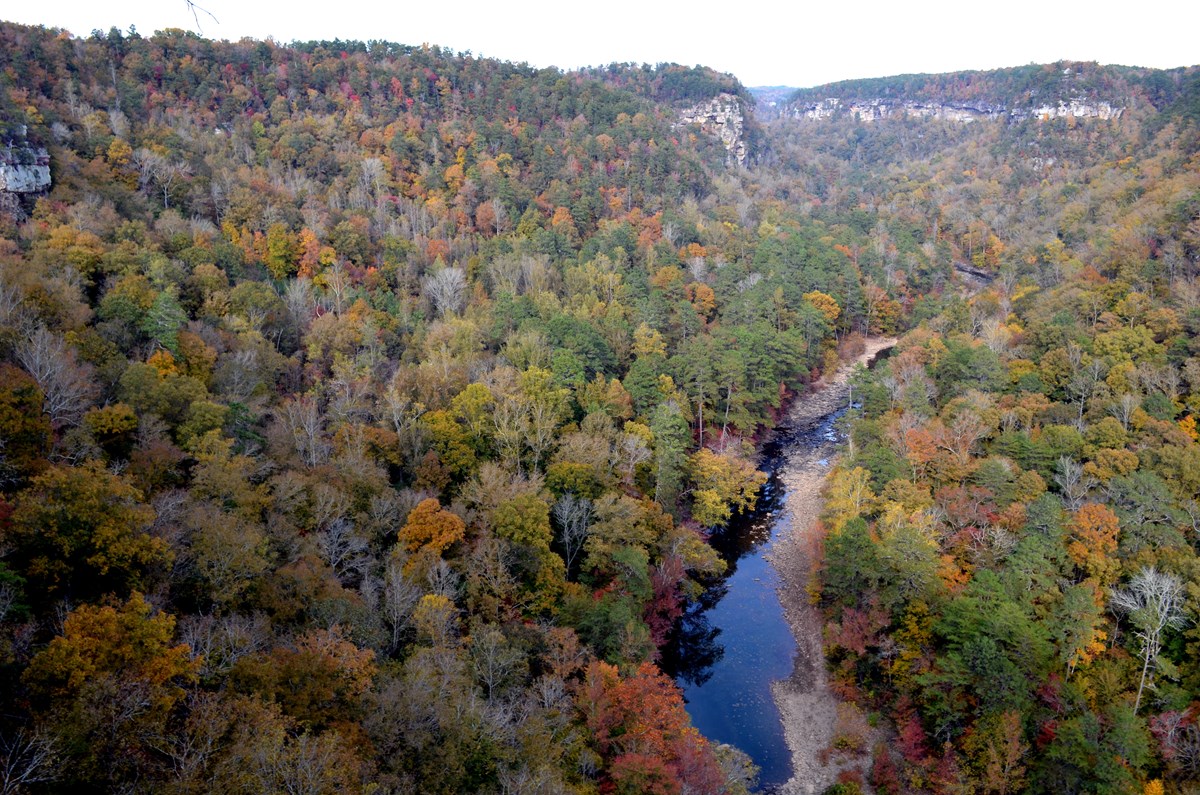
Photo from the managing agency (National Park Service). Confirm current conditions before you go.
A 15,000-acre sandstone canyon on Lookout Mountain about 10 miles east of Fort Payne: Little River Falls, a 23-mile rim parkway with eight overlooks, canyon swim holes, and a 4WD backcountry. Open sunrise to sunset with no entrance fee (except Canyon Mouth Park). There is no camping in the preserve — sleep at DeSoto State Park next door and drive in each morning.
Location
Research the approach roads and terrain here. When you're ready to drive, open directions in your preferred app below.
Research map · not turn-by-turn nav
34.39510, -85.62690 · ~1,200 ft
Get directions
Opens in the app you already use — we don't replace Apple Maps, Google Maps, or Waze.
Tip: download offline maps before you lose cell service in the woods.
Trip-ready check
Live · National Weather Service + National Park Service · updated 9:59 AMWhat to check the night before you leave — forecast, alerts, and daylight for Fort Payne, AL.
⛔ Backcountry Roads 8, 9, & 10 are closed
Attention visitors: Roads 8, 9, and 10 in the backcountry of the Wildlife Management Area (WMA) are currently closed for road maintenance. For your safety, please do not go around road barriers. Doing so is also a violation of Title 36 CFR Chapter 1 Part 1.1.5 (f) regarding road closures. Thank you for your understanding, and we apologize for any inconvenience.
ℹ SEASONAL SAFETY MESSAGE
Be careful and safe while out in the canyon! Be cautious of your surroundings, don't cliff jump, don't stray off of the main trails, and don't get too close to Little River Falls or the canyon rim. These activities could result in injury or death.
Today
70°F
Mostly Sunny
wind 0 to 5 mph
Tonight
46°F
Partly Cloudy
wind 0 mph
Tuesday
72°F
Sunny
wind 0 to 5 mph
Tuesday Night
47°F
Partly Cloudy
wind 0 mph
Wednesday
71°F
Partly Sunny
wind 5 mph
Wednesday Night
47°F
Partly Cloudy
wind 0 to 5 mph
Forecast: weather.gov point forecast · Park alerts: nps.gov. Conditions change — re-check the morning you leave.
What's actually allowed here
3 agencies govern this landYou cannot camp inside the preserve — but the official sources genuinely disagree, so here is all of it. Three NPS pages say camping is not permitted, and no campsites are designated, which is what makes it prohibited under 36 CFR 2.10. The catch: the newest and most authoritative document, the 2026 Superintendent's Compendium, literally reads “Camping is not prohibited” — with a justification that only makes sense for a prohibition. Its night closure of every lot and backcountry road settles it in practice. The preserve is also Little River Wildlife Management Area — a hunting overlay, not a camping permission — and Alabama's WMA rule independently bars camping except in designated sites, of which this WMA has none. Camp at DeSoto State Park, 15 minutes north, and drive in.
Who governs this ground
National Park Service — Little River Canyon National Preserve ↗
Owns and regulates the federal land (11,042 of the 15,288 authorized acres)
Alabama DCNR — Wildlife & Freshwater Fisheries ↗
Sets the hunting rules on Little River WMA — which the compendium describes as “that portion of the preserve identified by the State of Alabama as the Little River Canyon Wildlife Management Area”. Hunting only; it grants nothing about camping.
Forever Wild Land Trust / Alabama State Parks
Named as cooperators on the WMA permit, and the maps plot a separate private-land category — so more than one owner is involved. The exact geometry is unresolved: we could not verify published acreage from an official source.
Camping
- Not allowedNational Park Service — 36 CFR 2.10
Federal law is the backstop that settles this regardless of how the park's own wording reads: 36 CFR 2.10(a) lets a superintendent designate camping sites, and 2.10(b)(10) prohibits “camping outside of designated sites or areas.” Little River Canyon has designated no sites and operates no campground, so camping is prohibited by regulation.
Federal regulation — official eCFR current text ↗ · dated eCFR issue date 2026-08-13
- Not allowedNational Park Service — Superintendent's Compendium
The decisive current restriction is the night closure, not the camping paragraph: the compendium closes the preserve's non-gated parking lots, overlooks and backcountry roads during hours of darkness (30 min before sunrise to 30 min after sunset), with exceptions ONLY for licensed night hunting of raccoon, opossum and fox, and for fishing. There is no overnight-stay exception, which forecloses camping.
⚠ Heads up: this same document's § 2.10 paragraph literally reads “Camping is not prohibited within the Little River Canyon National Preserve” — while giving the justification “To protect the visitors and the resources within the preserve.” That is internally contradictory and reads like a dropped “not”. Do not treat it as permission; the night closure and 36 CFR 2.10 both point the other way. If you want to camp here, this is the ambiguity to raise on the phone.
Superintendent's Compendium (signed 05/27/2026) ↗ · dated July 7, 2026
- Not allowedNational Park Service — park camping page
The park states plainly: “Camping is currently not permitted at Little River Canyon National Preserve.” It points to DeSoto State Park (NPS says 7 miles north on this page and 10 on another — call it roughly 7 to 10 miles, tent/RV/backcountry sites) and privately run campgrounds around Fort Payne instead.
⚠ Five years old — corroborated here by the 2026 compendium rather than relied on alone.
Park web page ↗ · dated March 23, 2021
- Not allowedAlabama DCNR — WMA Regulation 220-2-.55(1)(m)
The state side reaches the same answer independently. Alabama makes it unlawful “to camp on any AREA except in designated sites,” capped at 9 days in any 30-day period. The official 2026–2027 Little River WMA permit designates no campsites and its map legend carries no campground or campsite symbol — so the WMA overlay creates no camping right either, on federal or non-federal parts of the WMA.
⚠ The official PDF prints no revision date, so the in-force version could not be confirmed.
State regulation (Ala. Admin. Code 220-2-.55) ↗ · date not shown on source
- Not allowedNational Park Service — Permits & Reservations
This closes the obvious loophole — “can I just get a permit?” No. The park's permits page, the freshest document in the whole record, lists every permit it issues: Special Use, Filming, and Commercial Use Authorization. There is no camping permit, no backcountry permit and no overnight permit, and the page never mentions camping.
Park web page ↗ · dated July 9, 2026
Why the nps.gov map looks like camping is allowed
- Unclearnps.gov Maps page (map authored by Alabama DCNR, not NPS)
Worth knowing before you trust the map: nps.gov publishes no NPS park map here at all — it hosts a state-authored hunting basemap, headed “Little River Canyon National Preserve Wildlife Management Area Map” and credited to the Alabama Department of Conservation and Natural Resources. That is also why the park reads as a WMA. Its legend does carry a “CAMP OR LODGE” symbol, but the one legible camp triangle sits beside the “DESOTO STATE PARK RESORT” label — measured entirely outside the shaded WMA area — so it marks DeSoto's camping, under Alabama State Parks, not a campsite in the preserve. The legend also lists “PRIMITIVE ROAD”, which is easy to read as “primitive camping”. The state's own 2020-2021 edition of this map already had no camping symbol, and neither does the current 2026-27 one, so the version nps.gov serves is at least two editions stale.
⚠ A map symbol is the weakest authority here — only the superintendent can designate a campsite, and that happens in the compendium, not on a basemap legend.
Official park web page hosting a state map ↗ · dated Page last updated November 29, 2020
Backcountry / primitive campsites (Slant Rock, Billy's Ford, Hartline Ford)
- Closed for nowNational Park Service — park FAQ
These three primitive sites did once exist in the backcountry and are the likely reason older maps and guides still show camping here. NPS closed all of them: “Little River Canyon National Preserve has closed all backcountry campsites for health and safety reasons… the pit toilets at the sites are unserviceable… We do not have a date for opening new campsites at this time.” Separately, Slant Rock Road is currently closed to vehicles (hike or bike in).
Park FAQ + conditions page ↗ · dated FAQ March 26, 2021; conditions May 28, 2026
Hunting (why this land is also a WMA)
- Only with conditionsAlabama DCNR — Wildlife & Freshwater Fisheries
This is what the WMA designation is actually for. NPS manages the preserve's Backcountry Area as Little River Wildlife Management Area in cooperation with Alabama DCNR, Alabama State Parks and the Forever Wild Land Trust; the state sets the hunting rules and requires deer and turkey harvests to be reported within 48 hours. The WMA is a hunting-management overlay — not a separate campable parcel.
You need: Alabama hunting licence + WMA licence, plus the free area permit and a daily permit (or the Outdoor Alabama WMA check-in app). Hunter education required if born on or after 1977-08-01.
⚠ Licence fees change yearly and the official fee sheet is stale — confirm the price at purchase.
Park web page ↗ · dated May 28, 2026
Campfires
- Only with conditionsNational Park Service — Superintendent's Compendium
Fires are restricted to designated picnic-area fire rings and standing grills, using appropriate fuel. Fallen dead wood on the ground may be collected for those rings only; standing dead trees may not be cut, as they are habitat.
You need: Designated fire rings / standing grills in picnic areas only
Superintendent's Compendium ↗ · dated July 7, 2026
Swimming
- AllowedNational Park Service
Swimming and wading are a normal use here — Blue Hole, Little Falls and the pools below Little River Falls are the classic spots. You must stay 50 feet back from the brink of Little River Falls; that one is enforced, and people have died on the wet rock.
Park web page ↗ · date not shown on source
Drones
- Not allowedNational Park Service — Superintendent's Compendium
Launching, landing or operating unmanned aircraft anywhere in the preserve is prohibited without written approval from the superintendent.
Superintendent's Compendium ↗ · dated July 7, 2026
OHVs / ATVs
- Not allowedNational Park Service
Off-highway vehicles — ATVs, UTVs and non-street-legal dirt bikes — are not allowed on any road in the preserve, including the 23 miles of backcountry WMA roads. Those roads are open to street-licensed 4WD vehicles, horses, bicycles and hikers, at an 11 mph limit.
Park web page + compendium ↗ · dated July 29, 2022
Double-check before you go
Rules change and pages go stale. One phone call beats any website — including this one.
- Preserve headquarters (the authority on what's allowed)256-845-9605official page ↗— ask specifically about camping; the compendium wording is ambiguous
- Current closures & conditionsofficial page ↗
- Alabama WMA hunting rules (state side)official page ↗
Immerse quotes official sources rather than paraphrasing them, and shows you when a source is stale or contradicts another. Where they conflict, we say so instead of picking the convenient answer.
Where to sleep nearby
There is no campground on this spot — these are the real options, closest first.
- DeSoto State Park — Improved Campground (94 hookup sites, tents welcome) →~15 min
Closest real camping. Reserve at reserve.alapark.com/desoto or call 256-845-5075. Check-in 2 PM.
- DeSoto State Park — Primitive Campground (18 walk-in tent sites) →~15 min
Quieter and wooded — fire rings, vault toilet, central water. Gate key at check-in.
- Cherokee Rock Village (Cherokee County / SCC, Leesburg) →~40 min
Has a first-come, first-served tent section at $19/night — no reservation needed if you're deciding late.
- Buck's Pocket State Park (Grove Oak) — 256-622-8400~45 min
23 RV sites + 11 primitive tent sites. Reserve at reserve.alapark.com/bucks-pocket. Verified alapark.com 2026-08-17.
Community pulse
Weekdays are calm; summer weekends fill the Falls lot by 11 AM. South of Eberhart Point the rim road (CR-275 to Canyon Mouth) is steep and winding — no trailers or RVs.
Everything you need to know
- Drive time (approx. from metro Atlanta / Conyers)
- ~2h 53m
- Access
- Any vehicle · paved road
- Hike-in
- Drive-up / no significant hike
- Pass required
- None for the preserve, Little River Falls, the Canyon Center or the Rim Parkway. $15/vehicle/day only at Canyon Mouth Park (America the Beautiful accepted).
- Parking
- Free — Little River Falls lot holds 100 cars with RV/bus spaces
- Camping
- NO camping anywhere in the preserve — day use only. Nearest camping: DeSoto State Park, 15 min north.
- Max stay
- Check local rules
- Reservation
- None for day use
- Elevation
- 1,200 ft
Must-sees & highlights
- ▸Little River Falls (45 ft) — boardwalk from the free lot west of the AL-35 bridge
- ▸Little Falls / Martha's Falls swim hole — 0.75 mi trail, 137 stone steps down
- ▸Blue Hole — calm, kid-friendly swim ¼ mi east of the Falls on AL-35
- ▸Canyon Rim Parkway (AL-176): Lynn, Hawks Glide, Canyon View, Wolf Creek, Crow Point, Eberhart
- ▸Mushroom Rock
- ▸Grace's High Falls (133 ft, tallest in Alabama) — rain-fed, usually dry in August
- ▸Eberhart Trail — 0.75 mi steep down to the river swim hole and old chairlift ruins
Amenities
Share your adventure
Link a YouTube video from your trip so others can see what the land feels like — and so parks can see real people loving their places.
Post YouTube adventure →